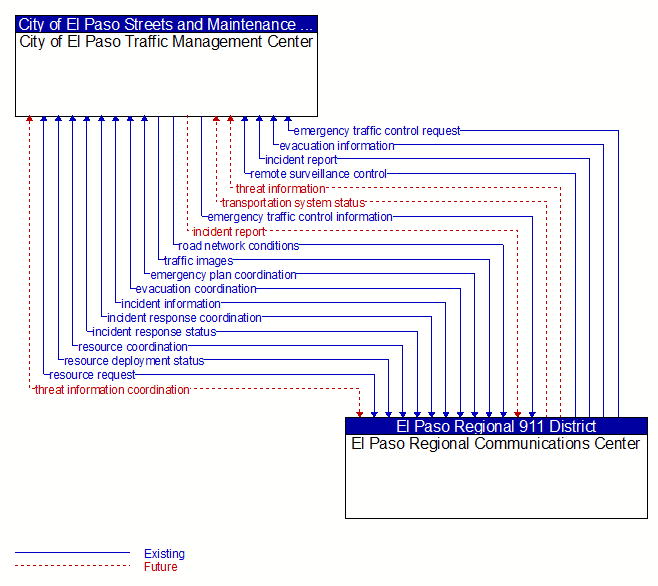
Interface: City of El Paso Traffic Management Center - El Paso Regional Communications Center
Architecture Flow Definitions
emergency plan coordination (Existing) Applicable ITS Standards
Information that supports coordination of emergency management plans, continuity of operations plans, emergency response and recovery plans, evacuation plans, and other emergency plans between agencies. This includes general plans that are coordinated prior to an incident and shorter duration tactical plans that are prepared during an incident.
emergency traffic control information (Existing) Applicable ITS Standards
Status of a special traffic control strategy or system activation implemented in response to an emergency traffic control request, a request for emergency access routes, a request for evacuation, a request to activate closure systems, a request to employ driver information systems to support public safety objectives, or other special requests. Identifies the selected traffic control strategy and system control status.
emergency traffic control request (Existing) Applicable ITS Standards
Special request to preempt the current traffic control strategy in effect at one or more signalized intersections or highway segments, activate traffic control and closure systems such as gates and barriers, activate safeguard systems, or use driver information systems. For example, this flow can request all signals to red–flash, request a progression of traffic control preemptions along an emergency vehicle route, request a specific evacuation traffic control plan, request activation of a road closure barrier system, or place a public safety or emergency–related message on a dynamic message sign.
evacuation coordination (Existing) Applicable ITS Standards
Coordination of information regarding a pending or in–process evacuation. Includes evacuation zones, evacuation times, evacuation routes, forecast network conditions, and reentry times.
evacuation information (Existing) Applicable ITS Standards
Evacuation instructions and information including evacuation zones, evacuation times, and reentry times.
incident information (Existing) Applicable ITS Standards
Notification of existence of incident and expected severity, location, time and nature of incident. As additional information is gathered and the incident evolves, updated incident information is provided. Incidents include any event that impacts transportation system operation ranging from routine incidents (e.g., disabled vehicle at the side of the road) through large–scale natural or human–caused disasters that involve loss of life, injuries, extensive property damage, and multi–jurisdictional response. This also includes special events, closures, and other planned events that may impact the transportation system.
incident report (Future) Applicable ITS Standards
Report of an identified incident including incident location, type, severity and other information necessary to initiate an appropriate incident response.
incident response coordination (Existing) Applicable ITS Standards
Incident response procedures and current incident response status that are shared between allied response agencies to support a coordinated response to incidents. This flow provides current situation information, including a summary of incident status and its impact on the transportation system and other infrastructure, and current and planned response activities. This flow also coordinates a positive hand off of responsibility for all or part of an incident response between agencies.
incident response status (Existing) Applicable ITS Standards
Status of the current incident response including a summary of incident status and its impact on the transportation system, traffic management strategies implemented at the site (e.g., closures, diversions, traffic signal control overrides), and current and planned response activities.
remote surveillance control (Existing) Applicable ITS Standards
The control commands used to remotely operate another center's sensors or surveillance equipment so that roadside surveillance assets can be shared by more than one agency.
resource coordination (Existing) Applicable ITS Standards
Coordination of resource inventory information, specific resource status information, resource prioritization and reallocation between jurisdictions, and specific requests for resources and responses that service those requests.
resource deployment status (Existing) Applicable ITS Standards
Status of resource deployment identifying the resources (vehicles, equipment, materials, and personnel) available and their current status. General resource inventory information and specific status of deployed resources may be included.
resource request (Existing) Applicable ITS Standards
A request for resources to implement special traffic control measures, assist in clean up, verify an incident, etc. The request may poll for resource availability or request pre–staging, staging, or immediate deployment of resources. Resources may be explicitly requested or a service may be requested and the specific resource deployment may be determined by the responding agency.
road network conditions (Existing) Applicable ITS Standards
Current and forecasted traffic information, road and weather conditions, and other road network status. Either raw data, processed data, or some combination of both may be provided by this flow. Information on diversions and alternate routes, closures, and special traffic restrictions (lane/shoulder use, weight restrictions, width restrictions, HOV requirements) in effect is included.
threat information (Future) Applicable ITS Standards
Threats regarding transportation infrastructure, facilities, or systems detected by a variety of methods (sensors, surveillance, threat analysis of advisories from outside agencies, etc.
threat information coordination (Future) Applicable ITS Standards
Sensor, surveillance, and threat data including raw and processed data that is collected by sensor and surveillance equipment located in secure areas.
traffic images (Existing) Applicable ITS Standards
High fidelity, real–time traffic images suitable for surveillance monitoring by the operator or for use in machine vision applications. This flow includes the images and meta data that describes the images.
transportation system status (Future) Applicable ITS Standards
Current status and condition of transportation infrastructure (e.g., tunnels, bridges, interchanges, TMC offices, maintenance facilities). In case of disaster or major incident, this flow provides an assessment of damage sustained by the surface transportation system including location and extent of the damage, estimate of remaining capacity and necessary restrictions, and time frame for repair and recovery.